The technology of Wayfinding, continued
A different concept is for the person who is blind to carry a tag similar to the ones used in shop security systems. Thus, machines can detect the presence of a person who is blind within a few feet and modify their behavior (e.g. give out a speech message). The tag or smart card can be pre-coded, which could indicate that the person would prefer messages in an alternative language.
Satellite navigation systems, such as GPS, can be used to determine one's position within a few feet. However, this requires line-of-sight to three or four satellites, which means being outdoors and not close to tall buildings. This position is just given as latitude and longitude, so it needs to be integrated with a detailed digital map of the area.
The availability of sufficiently detailed digital maps has proven to be a significant problem. Digital maps designed for car drivers do not give the detail needed by a pedestrian who is blind. Ideally the map should not just show the bus stop, but also provide information about which buses stop there.
Numerous wayfinding systems have been proposed, and many have been successfully developed to demonstrate the technical feasibility of the system. However, what is lacking is a clear plan for implementing systems and services so that users who are blind do not have to cope with different systems in each area.
Service animals
Service animals has *recently been redefined as dogs that are individually trained to perform tasks for people with disabilities such as guiding people who are blind, alerting people who are deaf, pulling wheelchairs, alerting and protecting a person who is having a seizure, or performing other special tasks. Service animals are working animals, not pets. *See this federal fact sheet.


Page 29 of 42
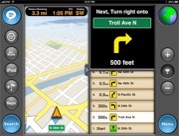
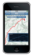
Devices, such as the iPad [upper] and iPhone [lower], receive signals from cellphone data towers and require no coordinates
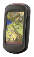
A GPS device, such as this Garmin, receives signals from up to 24 satellites and uses the data to establish a 3-dimensional position on earth
Next page
Previous page


ACCESS RECREATION GUIDELINES FOR COMMUNICATING TRAIL INFORMATION TO PEOPLE WITH DISABILITIES


Page 29 of 42
Next page
Previous page

