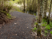
Graphic 3
An example of a moderate to difficult wooded trail
This page provides an overview of highest priority topics. Live links in the text take one directly to each topic.
Primary Information about trails – overview
This first part of the Guidelines identifies information that is considered minimal and mandatory for all information sharing whether on a webpage, on published materials or at the site itself. This information is descriptive of the existing conditions and therefore is obtainable and can be applied without cost. The categories described in greater detail include:
Contact information - whom does one contact to find out the latest condition of the trail or recreational features; whom does one contact to arrange for assistance; whom does one contact in case of an emergency.
Location information - where is the trail or recreational feature; where are parking and other amenities available; where are trailheads or points of arrival.
Considerations about the use of symbols on a webpage, on published materials or on signage at the site itself, taking into account that differences of color may not be suitable for all users. A combination of color, shape and readily comprehensible symbol design will provide the most universal application.
A rating system that presents relative levels of difficulty and the degree of exertion that may be required, applicable primarily for people with mobility impairments.
Identifying the amenities along a trail or recreational feature that may be useful in deciding whether to pick a particular trail or not, such as special views, benches or resting areas, *toilets, a *visitor center and available water. *Built facilities such as toilets and visitor centers need to conform to the ADA Accessibility Guidelines, and in the case of visitors centers, should incorporate the Smithsonian Guidelines for Accessible Exhibition Design.
A description of the overall trail itself as a continuous experience - a virtual tour - so that the potential user can decide whether to pick a particular trail or not.
A discussion about specific design elements and constraints such as typical and extreme slopes, cross slope and seasonal obstacles in the path.
Section 1


Page 1 of 42

See Examples 1 and 2 for a prototype webpage where all these topics have been assimilated.
Graphic 2
An example of 3 accessible feature symbols
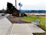
Graphic 1
Basic location information starts with the point of arrival


Next page
Previous page
ACCESS RECREATION GUIDELINES FOR COMMUNICATING TRAIL INFORMATION TO PEOPLE WITH DISABILITIES


Page 1 of 42


Next page
Previous page